WP1. Resilience under change
Aim
WP1 investigated how blue-green and grey systems can be co-optimised to offer maximum flood risk reduction, as well as multiple other benefits, under a range of future scenarios that account for climate and socio-economic changes.
Using state-of-the-art modelling methods, such as the fully coupled surface/sub-surface urban drainage model CityCAT, in conjunction to models developed throughout the project, WP1 helped to establish how integrated systems can deliver a service that is resilient to future uncertainty.
WP1 answered the question "what is the most effective mix of blue-green and grey systems in any given location at any time?"
Objectives
- Quantify performance of traditional and green infrastructure systems using novel and/or proven methods to trace flows, debris, sediments and pollutants from source to sink, while paying close attention to interfaces with other systems.
- Evaluate how proprietary SuDS devices (e.g. planters and filters) inter-operate with other assets.
- Undertake field surveys to identify opportunities and challenges with regard to installing (and retrofitting) these devices in the case study cities (WP5).
WP1 Research at Cambridge and Newcastle Universities
An adaptation pathways methodlogical guide for stakeholders (e.g. water companies, Lead Local Flood Authorities) was developed to illustrate flexible/adaptive design for long-term drainage infrastructure planning. Such an approach allowed incremental investments in infrastructure, matching the performance requirements while maintaining cost-effectiveness.
Hydrodynamic modelling work was led by Newcastle University using the in-house software (CityCAT) which solves overland 2D flow and sewer network flow under free surface and pressurised conditions.
Different rainfall inputs were tested to represent the effect of climate change and an increase in impermeable area with time represented the denser urban environment conditions expected in the future.
The possible interventions (e.g. swales, raingardens or grey infrastructure) were modelled separately or in combination to assess the different steps along the possible pathways (led by the University of Cambridge).
The methodology was tested in Sutton, a Borough of South London.
WP1 Research at Heriot-Watt University
Research at Heriot-Watt focused on the co-optimisation of traditional grey and blue-green infrastructure systems and built on their previous work on sediment, debris and pollutant dynamics in urban drainage systems.
Working with the Scottish Environment Protection Agency (SEPA), Scottish Water and West Lothian Council they investigated the feasibility of retrofitting SuDS to industrial, commercial and office premises at Houston Industrial Estate, a large development (over 100 businesses) which drains to a hydraulically-stressed constructed wetland.
The specific objectives of the study were to:
- Gauge awareness of SuDS technology and relevant regulations using a questionnaire
- Review literature and work with key stakeholders to identify the typical barriers to SuDS retrofit
- Work with business/land owners and West Lothian Council to understand what types of SuDS would be suitable within the risks and any constraints presented at the site
- Assess the willingness to install and evaluate the role incentives can play
- Produce case studies for Houston Industrial Estate which would allow the project findings to be easily transferred to other sites
WP1 Research at the University of Exeter
University of Exeter was involved in systematically evaluating urban water system flows in the demonstation case study Ebbsfleet, Kent (WP5) by adopting urban metabolism-based modelling. The quality of the urban metabolism is strongly influenced by its interconnectivity morphology; the modelling, therefore, embraces a whole system perspective that recognises interdependencies between water flows and other flows and fluxes in urban systems including wastewater, energy and material.
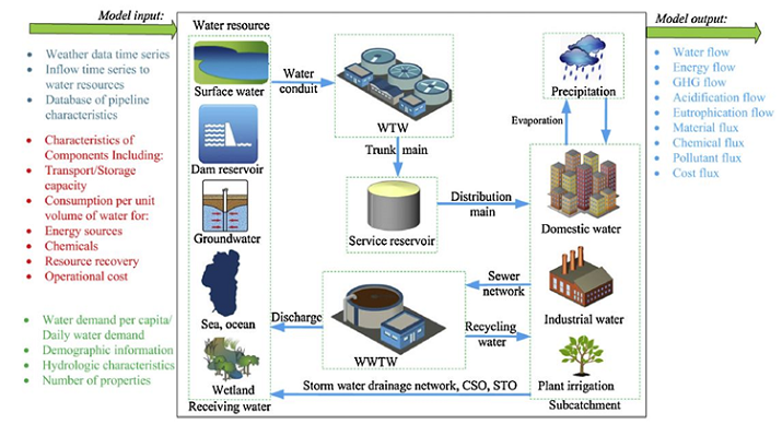
An urban metabolism model was developed to represent the urban water system in Ebbsfleet Garden City. The urban water system performance model, WaterMet2, is being used. This is a simulation, mass-balance-based model which provides fluxes in four subsystems: water supply, stormwater, wastewater, and water resource recovery.
Household rainwater harvesting (WP2) and grey water recycling was then integrated into the urban metabolim modelling, at the sub-catchment and city scales.
WP team